

Mirs Bay Pilotage
archive > archive documents
Resumption of Mirs Bay Pilotage – View of a Hong Kong Pilot
Introduction
The pilotage service in Mirs Bay has been resumed from 1st January of 2020. This article is to introduce the information and first-hand experience about the pilotage in the Mirs Bay area with analysis of the interaction between shipping activities and its potential impact in the area.
Pilotage service in Mirs Bay
With the resumption of pilotage service in the Mirs Bay, 3 pilot stations have been established, namely, Shek Ngau Chau, Crooked Island and Ping Chau. Vessels getting inbound, outbound or transiting the area are required to have pilot onboard from the above pilot stations.
There are 3 reasons in the legislative proposal in justifying the resumption of pilotage service in Mirs Bay. First is that all Hong Kong waters are pilotage area. The remaining are that the LNG berths in Mirs Bay has been built and substantial increase in size and density of vessels calling port of Yantian.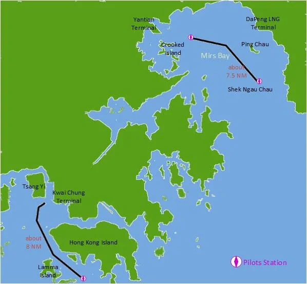
Environment and leisure activities within Mirs Bay
Mirs Bay is an area about 335 kilometers square. It includes the waters of Shenzhen, which is at the Northeast part of the bay, and waters of the HKSAR of China, which is at the Southwest side of the bay. It is the eastern part of Hong Kong and separated from the Victoria Harbour and Kwai Chung Terminal by the land mass of Hong Kong.
It is a bay with beautiful environment with tourist spots, marine parks and UNESCO Global Geopark. It is an area comprises of scenic coastal areas, seascapes and important marine habitats with high and peculiar ecological value.
There are 3 marine parks in the Mirs Bay area, namely, Hoi Ha Wan, Yan Chau Tong and Tong Ping Chau. Marine Parks are areas defined under the Marine Parks Ordinance which objective is to protect the high and distinct environmental and ecological values of the areas. There are mangroves, coral communities, seagrass bed and rich diversity of marine lives in the 3 marine parks in Mirs Bay. The best coverage of stony coral, which is of high ecological value, were found in the Tong Ping Chau Marine Park.
Crooked Island and Tung Ping Chau are areas included in Hong Kong UNESCO (United Nations Educational, Scientific and Cultural Organization) Global Geopark. Geopark is an area which is a natural area of special geological significance and natural beauty with significant coverage and scope of geoheritage. Geoparks are unified geographical areas where sites and landscapes of international geological significance.
Da Mei Sha Park is one of the most famous beaches in China, which is called the Eastern Hawaii. The beach located at the north part of the Mirs Bay within the Shenzhen waters. It is one of the most famous tourist spots in China.
Both the Guangdong and Hong Kong governments have worked hard on protecting the Mirs Bay environment. In 2000, the Hong Kong and Guangdong Governments jointly established the Mirs Bay and Deep Bay (Shenzhen Bay) Areas Environmental Management Special Panel under the Hong Kong-Guangdong Joint Working Group on Sustainable Development and Environmental Protection to strengthen cooperation to protect the water environment of Deep Bay and Mirs Bay. the two sides conducted research on the environmental protection aspect and regional control strategy for Mirs Bay. In 2003, the Environmental Protection Department of Hong Kong and the Shenzhen Environmental Protection Bureau (now renamed as the Human Settlements and Environment Commission) jointly completed the “Mirs Bay Water Quality Regional Control Strategy” study and recommended that an upper limit should be put on the development of Mirs Bay so as to protect the water quality of the bay.
Shipping activities in Mirs Bay
The shipping activities do not fit in easily with the invaluable natural environment of Mirs Bay. There are container terminals, tankers terminals, LNG terminals and several anchorage areas.
The container terminal at Yantian is one of the busiest container terminals in the world. The annual throughput of Yantian is more than 13 million TEU in 2018 and expected to increase steadily. The largest container vessels like MSC Gulsun, Madrid Maersk and OOCL Hong Kong have called the port of Yantian.
In addition to the services to major shipping lines, the Yantian port is also providing feeder services between Yantian, Pearl River Delta and South China Coast and its hinterland. These services are mainly provided by coastal vessels and barges.
There are also LNG and tanker berths located in different areas in Mirs Bay. The Guangdong Dapeng LNG Terminal, which can accommodate the largest LNG carriers in the world up to 260,000 cubic meters, situated 1.5 miles north of Ping Chau. The Xiaodong Harbour contains 3 LPG terminals, which serve tankers range from 5,000 dwt to 100,000 dwt. All these tanker facilities safeguard the energy source for the city of Shenzhen.
There is an oil terminal, which serves tankers up to 213m LOA, within the Tolo Harbour of Hong Kong. In addition, there are cement vessels anchor at Tolo Harbour on occasions.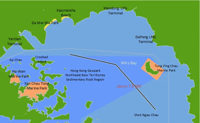
Traffic in Mirs Bay and its impact
From the above facts, it can be seen that shipping facilities are located in different locations all round the Mirs Bay. There are tanker and LNG terminals on the eastern coast, Yantian Container terminal on the north coast and tanker berth within the Tolo Harbour. So vessels going into and from the port facilities are coming from different directions and going for different destinations. In this sense, the traffic pattern in Mirs Bay is complex. There is convergence of different routes. Close quarter situations, resulting from overtaking, crossing and head on situations, are totally foreseeable.
The room for maneuvering is not as open as in the high sea. There are shallow spots in the Mirs Bay. There are coasters and barges in the area which affect the maneuvering of vessels. There are also a lot of fishing and leisure activities in the Mirs Bay.
While the Tokyo Bay and Osaka Bay have the areas of 1500 and 1400 kilometers square, the area of Mirs Bay of 335 kilometers square is substantially less than Tokyo Bay and Osaka Bay. With one of the busiest ports in the world, Yantian Container Terminal, located in the Mirs Bay area, the presence of navigational risks in far from negligible. If there are bay pilots in much larger areas like Tokyo Bay and Osaka Bay, pilotage in the Mirs Bay is fully justified and necessary.
In addition to the concern of navigable waters, the environmental value of the area also justifies the pilotage in the Mirs Bay. The best example for comparison is perhaps the Great Barrier Reef pilots of Australia. The Great Barrier Reef pilots’ fundamental obligation is to protect the Great Barrier Reef marine park and the world heritage area. With the presence of marine parks, coral communities and geoheritage sites in the Mirs Bay, the same pilotage measure is deserved to protect the environment of Mirs Bay.
Conclusion
The navigable waters in Mirs Bay are not without restriction and the navigation patterns are complex. The Mirs Bay consists of many areas which are of high environmental value and are irreplaceable. Any navigation incident may result in disastrous impact to the environment. The area deserves to be better protected by additional navigational measures. The development of shipping activities must be balanced with the protection of environment. Resumption of pilotage in Mirs Bay is one of the correct measures in promoting such objective. The Hong Kong Marine Department is steering the right course in safeguarding the navigational safety and environment of the Mirs Bay.